BEAUMONT, Texas — Severe storms moved through Southeast Texas early Wednesday morning leaving many without power.
The line of fast-moving storms packed wind gusts up to 70 mph, a lot of lightning and even hail.
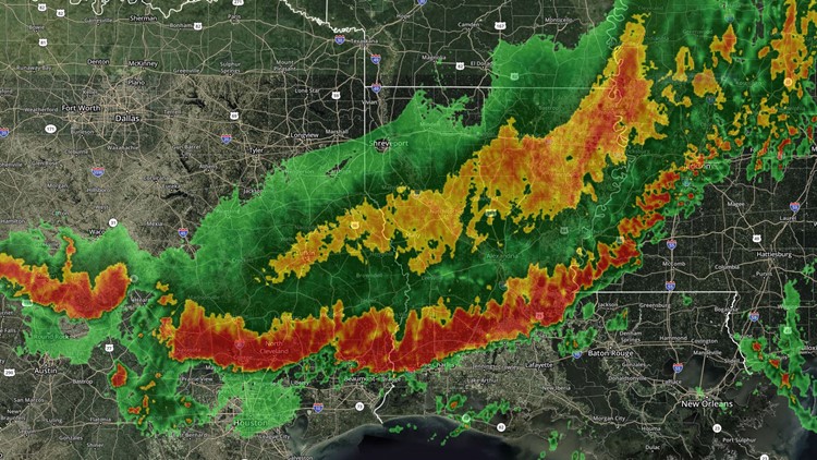
By about 6 a.m. Wednesday the main line of the storms were moving into the Gulf of Mexico.
The line of strong storms hit the lakes area of Southeast Texas around 3 a.m. and by about 4:15 a.m was passing over Beaumont according to the 12News StormTracker radar.
Power outages were left in the wake of the storm line and at 6:15 a.m. more than 15,000 Entergy customers were left without power.
Southeast Texas Power Outages at 4:00 p.m.
- Jefferson County 2,809
- Hardin County 365
- Orange County 433
- Liberty County 79
- Tyler County 45
MORE | Entergy Outage Map
At about 6:25 a.m. more storms were passing over Beaumont but the StormTracker radar shows them dissipating by about 9 a.m.
Damaging winds were the primary threat, according to 12News Chief StormTracker Meteorologist Patrick Vaughn. Those considered 'damaging' would be 60 mph or greater.
There is a slight risk of additional flash flooding over Southeast Texas Tuesday night through 7 a.m. Wednesday. The expected squall line will be moving very quickly, lowering the chance for flooding rains.
The hail and tornado threat is low but still possible, the National Weather Service out of Lake Charles says.
A Severe Thunderstorm Watch has been issued just north of the Southeast Texas Lakes Area until 9 a.m. Wednesday.
South of Beaumont, including mid-county as well as Chambers Co. are under a slight risk for severe weather. The primary threats here include short-lived isolated intense storms.
STORM TIMELINE
WEDNESDAY 2 a.m. — Severe weather remains north of the Lakes area and will be impacting Montgomery and Walker Co. NOW IS THE TIME TO START WATCHING THE RADAR FOR ANY SEVERE ACTIVITY.
WEDNESDAY 4 a.m. — Severe thunderstorms will begin impacting the Lakes area including parts of Tylers, Jasper and Newton Co. and moving into the Triangle.
WEDNESDAY 6 a.m. — The worst of the weather should moving toward the coast and out of our area, although many of our coastal communities only have a slight risk of severe weather.
WEDNESDAY 10 a.m.— Scattered showers and a few storms continue through the morning.
WEDNESDAY 12 p.m. — By lunchtime and the afternoon the rain chance drops dramatically, leaving only cloudy skies.
WHAT TO EXPECT
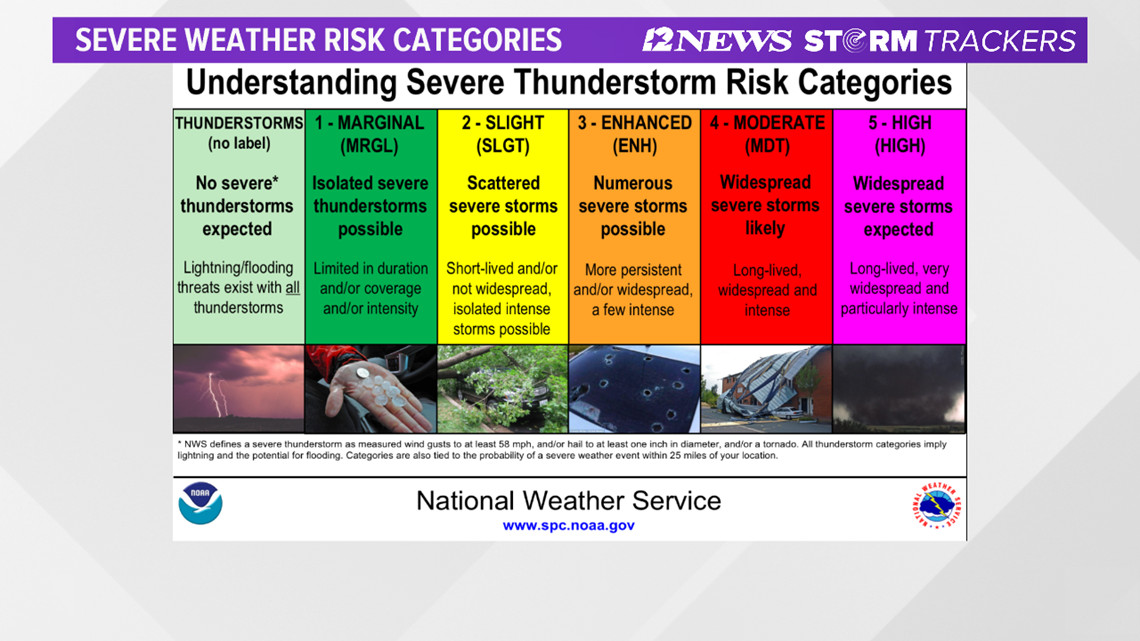
The Storm Prediction Center has a majority of Southeast Texas area in a 'enhanced risk' (3 out of 5). Areas south of I-10 are under a 'slight risk" (2 out of 5). The 12News StormTrackers will be tracking the potential for strong straight line damaging winds ahead of a cold front that will be pushing through overnight.
This is what is called a "bow-echo" wave pattern. While there is a chance for tornadoes, straight line winds are the primary threat.