
BEAUMONT, Texas — A line of severe thunderstorms passed through Southeast Texas Sunday afternoon drenching portions of the region and blanketing some with up to golf ball-sized hail.
All of Southeast Texas and portions of western Louisiana were placed on a tornado watch through 7 p.m. Sunday.
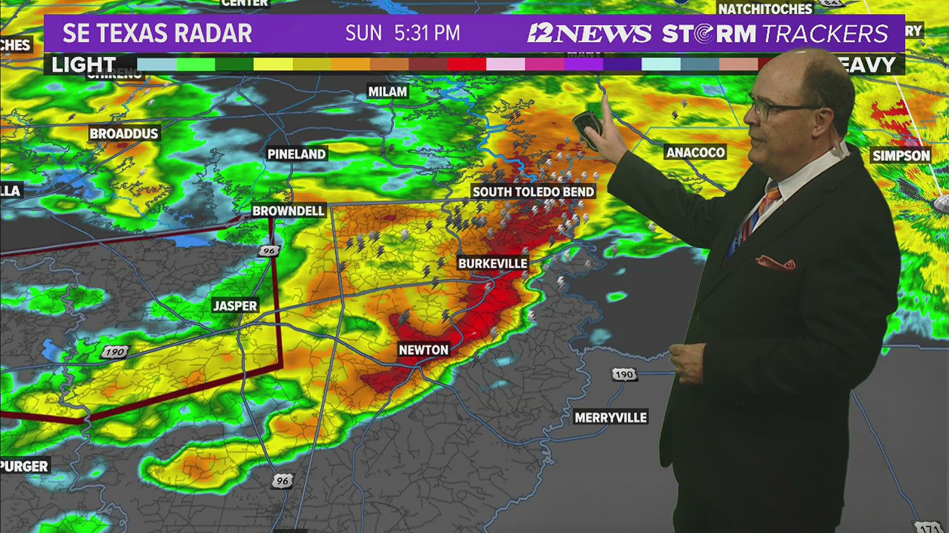
Earlier in the afternoon the National Weather Service reported a moderate risk of excessive rainfall across Southeast Texas and into western Louisiana as well as slight risk of severe weather Sunday afternoon.
Showers and storms were forecast increase today though Monday as a series of upper level disturbances move across the region along with a warm front. One to three inches of rain were forecast as possible in the Triangle and three to six inches in the Lakes by Monday evening.
The NWS has issued the following weather alerts for Southeast Texas...
Some highlights and key messages for TODAY's weather: A moderate risk for excessive rainfall is now across southeast Texas into western Louisiana. A Flood Watch is in effect. There is also a Slight Risk for severe weather today and this afternoon. Be weather aware today/tonight!
A break in the rain Tuesday and Wednesday before the next system moves into the area Thursday.
Golf-ball sized hail falling throughout SETX


Watch our live weather loop
Short Term Forecast
Triangle Sunday Night: Mostly cloudy, mild and humid. A 30% coverage of showers and thunderstorms. Low near: 75° in Beaumont, near: 75° in Orange and 76° in Port Arthur. Winds: South/southEast: 5-10 mph.
Lakes Area Sunday Night: Mostly cloudy, mild and humid. A 50% coverage of showers and thunderstorms. Low near: 66°. Winds: East/Southeast 5-10 mph.
Triangle Monday: Cloudy, warm, humid. An 80% coverage of showers and thunderstorms. Some severe. High near: 83° in Beaumont, near: 83° in Orange and near: 80° in Port Arthur. Winds: South/Southwest 5-15 mph.
Lakes Area Monday: Cloudy with a 90% coverage of showers and storms. Some severe in the afternoon. Humid. High near: 76°. Winds: South/Southwest: 5-15 mph.
Extended Forecast
Tuesday (5/14): Mostly sunny, warm and less humid. Low near: 66°. High near: 88°. Winds: Northwest: 5-10 mph.
Wednesday (5/15): Mostly sunny, warm. Low near: 63°. High near: 88°. Winds: East becoming Southeast: 5-15 mph.
Thursday (5/16): Mostly cloudy, warm, humid and breezy with a 70% coverage of showers and thunderstorms. Low near: 70°. High near: 78°. Winds: Southeast: 10-15 mph with gusts to 20 mph.
Friday (5/17): Becoming mostly sunny, warm and breezy. A 20% coverage early. Low near: 70°. High near: 88°. Winds: Southwest becoming South: 10-15 mph with gusts to 20 mph.
Saturday (5/18): Mostly sunny, warm and humid. Low near: 70°. High near: 87°. Winds: Southeast becoming South: 5-15 mph.
Sunday (5/19): Partly cloudy, warm and humid. A 40% coverage of showers and storms. Low near: 71°. High near: 83°. Winds: South to Southeast: 5-15 mph.
Monday (5/20): Partly cloudy, warm, humid and breezy. A 40% coverage of storms. Low near 73°. High near 84°. Winds: South: 5-15 mph with gusts to 20 mph.
Tuesday: (5/21): Partly cloudy. with highs near 90. Winds: South 10-15 mph.
Wednesday (5/22): Partly cloudy. Lows: 75. Highs: 90. Winds: South 10-15 mph