
BEAUMONT, Texas —
Forecast Discussion
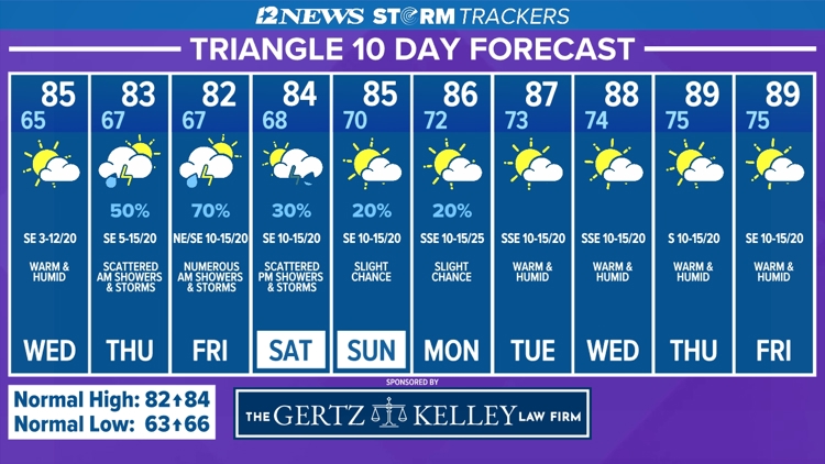
Patchy fog is possible across SE Texas Wednesday Morning with a warm, dry afternoon.
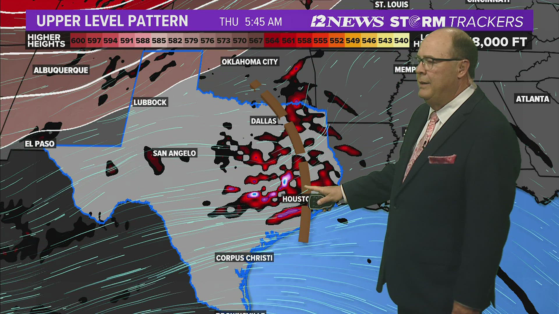
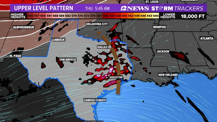
Scattered to possibly numerous showers and thunderstorms are expected Thursday Morning due to an upper-level disturbance.
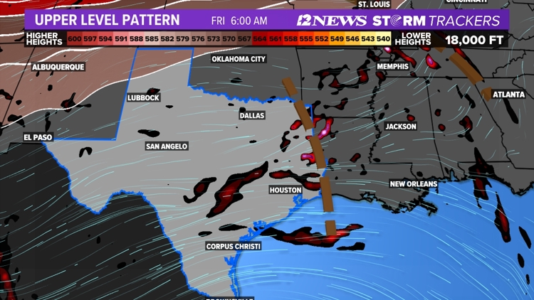
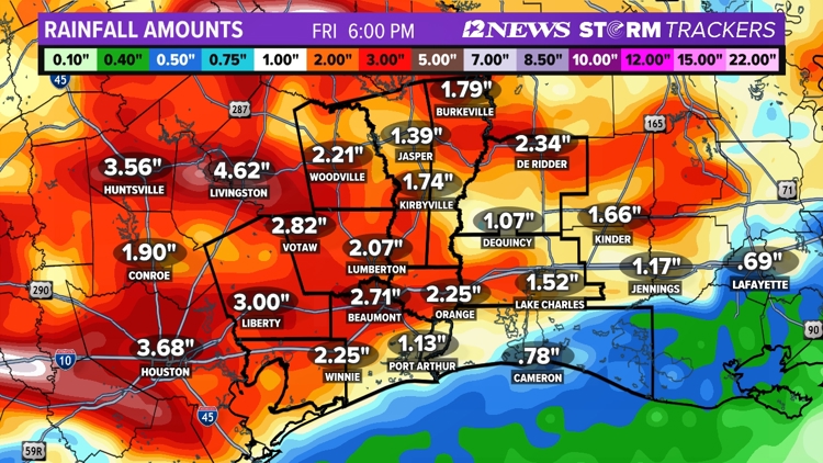
Another round of numerous, morning showers and thunderstorms is forecast Friday due to another upper level-disturbance.
Saturday, scattered to possibly numerous afternoon showers and thunderstorms are forecast.
Sunday and Monday, a slight chance of showers and thunderstorms is forecast.
Tuesday the 7th through Friday the 10th looks dry with warming temperatures.
Southeast Texas weather


Short Term Forecast
Triangle Tuesday Night: Partly cloudy, mild and humid with patchy fog. Low near: 65° in Beaumont, near: 64° in Orange and 66° in Port Arthur. Winds: Southeast becoming East: 2-7 mph.
Lakes Area Tuesday Night: Partly cloudy, cool and humid with patchy fog. Low near: 63°. Winds: Southeast: 2-7 mph.
Triangle Wednesday: Morning cloudiness and patchy fog followed by a partly cloudy, warm, humid and breezy afternoon. High near: 85° in Beaumont, near: 85° in Orange and near: 84° in Port Arthur. Winds: Southeast: 3-12 mph with gusts to 20 mph.
Lakes Area Wednesday: Morning cloudiness and patchy fog followed by a partly cloudy, warm, humid afternoon. High near: 86°. Winds: Southeast: 3-15 mph.
Extended Forecast
Thursday (5/2): 50% coverage of morning showers and thunderstorms in the Triangle and an 80% coverage in the Lakes Area followed by a partly sunny, warm, humid, breezy afternoon. Low near 67°. High near 83°. Winds: Southeast: 5-15 mph with gusts to 20 mph.
Friday (5/3): 70% coverage of morning showers and thunderstorms followed by warm, humid, breezy afternoon with decreasing cloudiness. Low near: 67°. High near 82°. Winds: Northeast becoming Southeast: 10-15 mph with gusts to 20 mph.
Saturday (5/4): Warm morning followed by a partly sunny, warm, humid, breezy afternoon with a 30% coverage of showers and thunderstorms in the Triangle and a 60% coverage in the Lakes Area. Low near: 68°. High near 84°. Winds: Southeast: 10-15 mph with gusts to 20 mph.
Sunday (5/5): Warm morning followed by a partly cloudy warm, humid, breezy afternoon with a 20% coverage of showers and thunderstorms. Low near: 70°. High near: 85°. Winds: Southeast: 10-15 mph with gusts to 20 mph.
Monday (5/6): Warm morning followed by a partly cloudy, warm, humid windy afternoon with a 20% coverage of showers and thunderstorms. Low near: 72°. High near: 86°. Winds: South-Southeast: 10-15 mph with gusts to 25 mph.
Tuesday (5/7): Warm morning followed by a partly cloudy, warm, humid breezy afternoon with a 20% coverage of showers and thunderstorms. Low near: 73°. High near: 87°. Winds: South-Southeast: 10-15 mph with gusts to 20 mph.
Wednesday (5/8): Warm morning followed by a partly cloudy, warm, humid, breezy afternoon. Low near: 74°. High near: 88°. Winds: South-Southeast: 10-15 mph with gusts to 20 mph.
Thursday (5/9): Warm morning followed by a partly cloudy, warm, humid, breezy afternoon. Low near: 75°. High near: 89°. Winds: South: 10-15 mph with gusts to 20 mph.
Friday (5/10): Warm morning followed by a partly cloudy, warm, humid, breezy afternoon. Low near: 75°. High near: 89°. Winds: Southeast: 10-15 mph with gusts to 20 mph.