
BEAUMONT, Texas —
NOTE: This article is no longer being updated. Find the latest on now Hurricane Ida here.
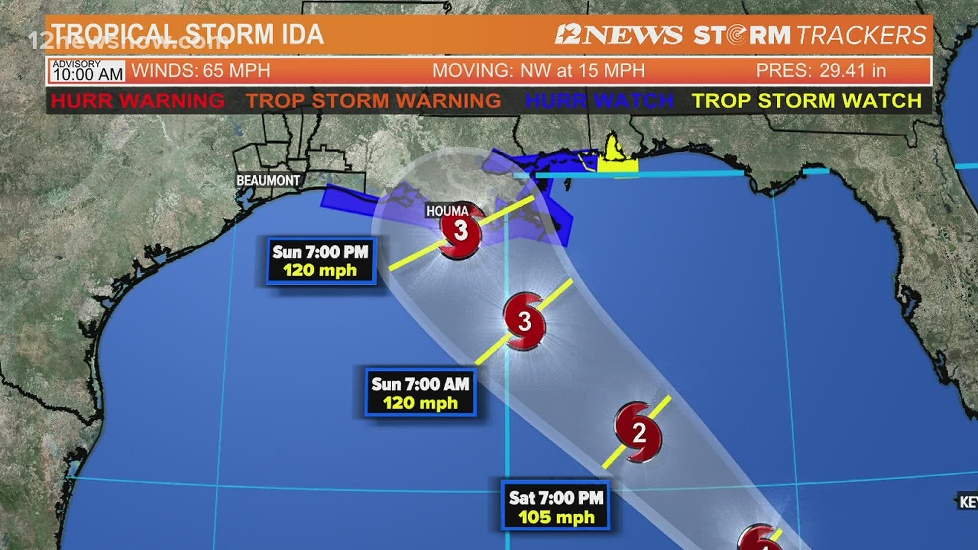
Tropical Storm Ida is growing stronger.
The National Hurricane Center says Ida is showing hallmarks of a rare, rapidly intensifying storm that could speed across warm Gulf waters and slam into Louisiana as a major hurricane on Sunday.
Louisiana Gov. John Bel Edwards has declared an emergency for all of Louisiana and says everyone in the danger area should be in a safe place to ride out the storm by Saturday night.
The NHC said in their 4 a.m. advisory Friday they expect the system to approach the northern Gulf coast with a landfall in Louisiana likely on Sunday, the anniversary of Hurricane Katrina.
Impacts on Southeast Louisiana
On Saturday, we will see hit-or-miss storms through the afternoon, but then squalls will move in late Saturday night. We still don't expect widespread issues through Saturday night, but rounds of rain will start to filter in.
By Sunday, we will be watching Ida bear down on the Gulf Coast. Sunday morning, conditions will start to go downhill near the Louisiana coast as Ida moves in.
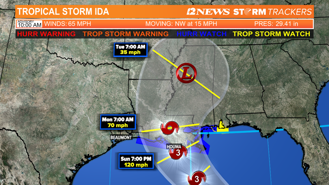
Ida is expected to make landfall Sunday afternoon to evening near Terrebonne Parish as a Category 3 hurricane. Conditions will go downhill Sunday with the worst of the storms expected Sunday late afternoon and into the evening.
Winds will decrease as Ida moves inland, but areas from New Orleans and to the west could experience 80+ mph winds. The Northshore could see winds of 60-80 mph.
Storm surge could reach 7-11 feet Sunday evening. The lakes could experience 2-5 feet rise. Heavy rain will also be a threat with perhaps some areas seeing more than 10 inches of rain.
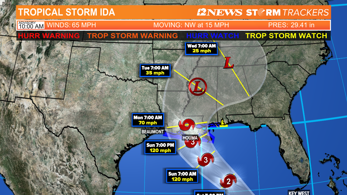
By Monday, Ida will likely still be in the region as it moves to the north into Central Louisiana and Mississippi. We'll likely still see some rain and windy conditions.


Watches and Warnings:
- A hurricane watch is in effect from Camera, La. to the Mississippi-Alabama border, including metropolitan New Orleans.
- A tropical storm watch is in effect from the Mississippi-Alabama border to the Alabama-Florida border.
- A storm surge watch is in effect from Sabine Pass to the Alabama-Florida border.
A hurricane watch is typically issued 48 hours before the anticipated first occurrence of tropical-storm-force winds, conditions that make outside preparations difficult or dangerous.
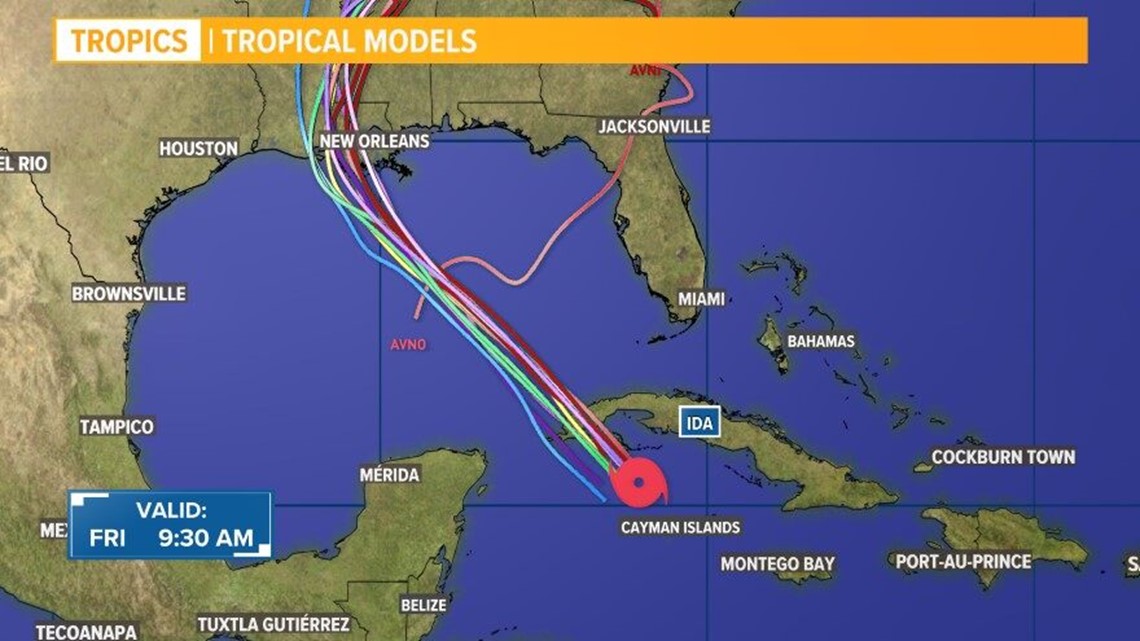
Tropical Storm Ida spaghetti models:


National Hurricane Center's Thursday 10 a.m. Central update...
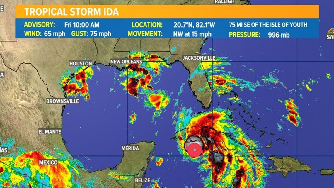
At 1100 AM EDT (1500 UTC), the center of Tropical Storm Ida was located near latitude 20.7 North, longitude 82.1 West. Ida is moving toward the northwest near 15 mph (24 km/h), and this general motion should continue over the next few days.
On the forecast track, the center of Ida will pass near or over the Isle of Youth and western Cuba later today, and move over the southeastern and central Gulf of Mexico tonight and Saturday.
Ida is forecast to make landfall along the U.S. northern Gulf coast within the hurricane watch area on Sunday.
Reports from Air Force and NOAA reconnaissance aircraft indicate that the maximum sustained winds have increased to near 65 mph (100 km/h) with higher gusts.
Additional strengthening is forecast today and Ida is expected to be a hurricane when it nears western Cuba later today. Steady to rapid strengthening is expected when Ida moves over the southeastern and central Gulf of Mexico over the weekend, and Ida is expected to be a major hurricane when it approaches the northern Gulf coast.
Tropical-storm-force winds extend outward up to 90 miles (150 km) from the center. A wind gust to 45 mph (72 km/h) was recently reported on Cayman Brac and a wind gust to 41 mph (67 km/h) has been observed on Cayo Largo, Cuba, within the past hour or two.
The latest minimum central pressure reported by an Air Force Reserve reconnaissance aircraft is 996 mb (29.42 inches).

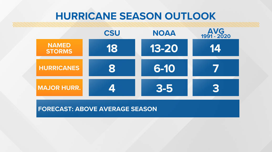
2021 Hurricane Season Outlook
The 2021 Atlantic Hurricane Season is forecast to produce more storms than average. The reason for this is the lack of El Nino, which typically features more wind shear. We also expect warmer than average sea temperatures and an active West African Monsoon.

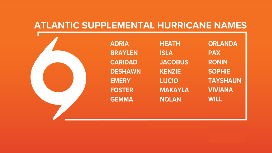
After a record-breaking 2020 hurricane season, we now know the Greek alphabet will no longer be used to name storms.
The World Meteorological Organization announced the Greek alphabet will not be used in the future because it "creates a distraction from the communication of hazard and storm warnings and is potentially confusing."

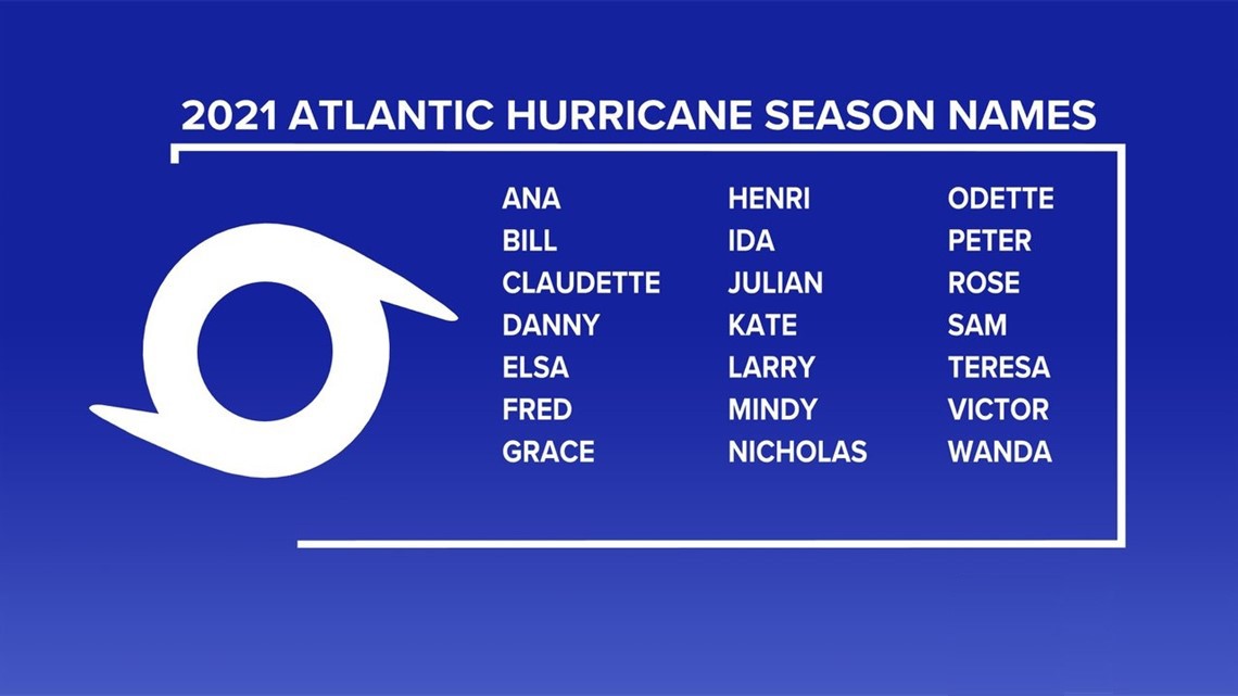
There has been only one other season that used the extra set of names, and that was in 2005. The World Meteorological Organization released a new set of supplemental names that will be used if the season exhausts the standard list.

Be prepared if a storm comes our way
BEFORE THE STORM
- Make a home inventory
- Have a current copy of your declarations page that has your policy number and your agent's number
- Review your policy with your insurance agent to determine if you have adequate coverage
- Repair loose boards, shingles, shutters and downspouts to prevent them from becoming an issue in high winds or torrential rain
- Have an evacuation plan, and include plans for your pets
- Make sure your emergency equipment is in working order, including a battery-powered radio, flashlights and extra batteries. Also, make sure to gather all medicine, replenish your first-aid kit and stock a week's worth of non-perishable food and water
- Charge your cell phone and fill your car with gas
- Program all emergency phone numbers
DURING THE STORM
- If you are advised to evacuate, leave as soon as possible. Retain all related receipts - they may be considered in your claim. If you aren't in a recommended evacuation and you plant to stay home, stay informed by listening to weather alerts
- Keep windows and doors closed at all time, and, if possible, board them up with wooden or metal shutters
- Stay away from the windows and in the center of the room, or, stay in an interior room
- Avoid flood water, as it may be electrically charged from downed power lines
- Check on family members and friends
AFTER THE STORM
- Check to be sure your family members are safe
- If you did evacuate, wait for official notice that it is safe to re-enter your neighborhood and your house
- Document damaged property, and take photos and videos. Don't dispose of any damaged items without approval
- Keep a record of any temporary repairs or expenses to prevent further damage to your property.
GET NEWS & WEATHER ALERTS | Download the 12News App to your mobile device