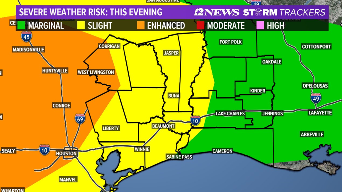
BEAUMONT, Texas — Southeast Texas is under an increased threat for severe weather Thursday night.
The National Weather Service has now expanded the "enhanced risk" zone to include portions of Liberty Co. All other counties in Southeast Texas are under a the "slight" zone.
StormTracker Chief Meteorologist Patrick Vaughn says today's highs are near 90-degrees and that is increasing the storm threat.
"This will further increase instability," Vaughn said.

What to expect
At minimum, it appears heavy rain, lightning and thunder will be pretty widespread with some rain rates in the heavier storms as high as 1 to 2 inches of rain per hour.
There is the possibility that some storms could become severe. Large hail, strong damaging winds and heavy rainfall are all possible threats for our area.
Areas closer to Houston could see up to 2" hail, strong downburts and flash flooding.
Timeline: When to expect the storms
4 PM — Sunny, hot across Southeast Texas. Slight chance of showers in and around the Lakes.
6 PM — Rain chances increase; Some western edges of our viewing area could begin to experience isolated storms. Now is the time to watch the radar.
7 PM — The line of strong storms will begin arriving into the Lakes area. Heavy rain, strong winds and severe storms are possible.
8 PM — The strong storms arrive in the Triangle. Beaumont and surrounding areas can expect heavy rain and the possibility of isolated severe storms.
10 PM — Light showers continue overnight into the very early morning hours Friday.
What to expect Friday through Easter weekend
For Friday, the front will be past us, but still lingering nearby, says StormTracker Chief Meteorologist Patrick Vaughn. As high pressure moves from the Central Plains to the Mid Mississippi River Valley, we'll have a cool, northeasterly breeze. If we couple that with the cloud cover, and scattered showers, we'll see our air feel chilly and temps run in the 60s most of the day.
Saturday (4/11): Mostly cloudy, warm, humid, breezy with a 40% coverage of showers and thunderstorms increasing to a 80% coverage late. Low near: 60°. High near: 76°. Winds: Southeast 5-15 mph with gust to 20 mph.
Easter Sunday (4/12): 60% coverage of morning showers and thunderstorms then, afternoon clearing, breezy with lower humidity. Low near: 68°. High near: 84°. Winds: West 5-15 mph with gusts to 25 mph.