
BEAUMONT, Texas —
Forecast Discussion
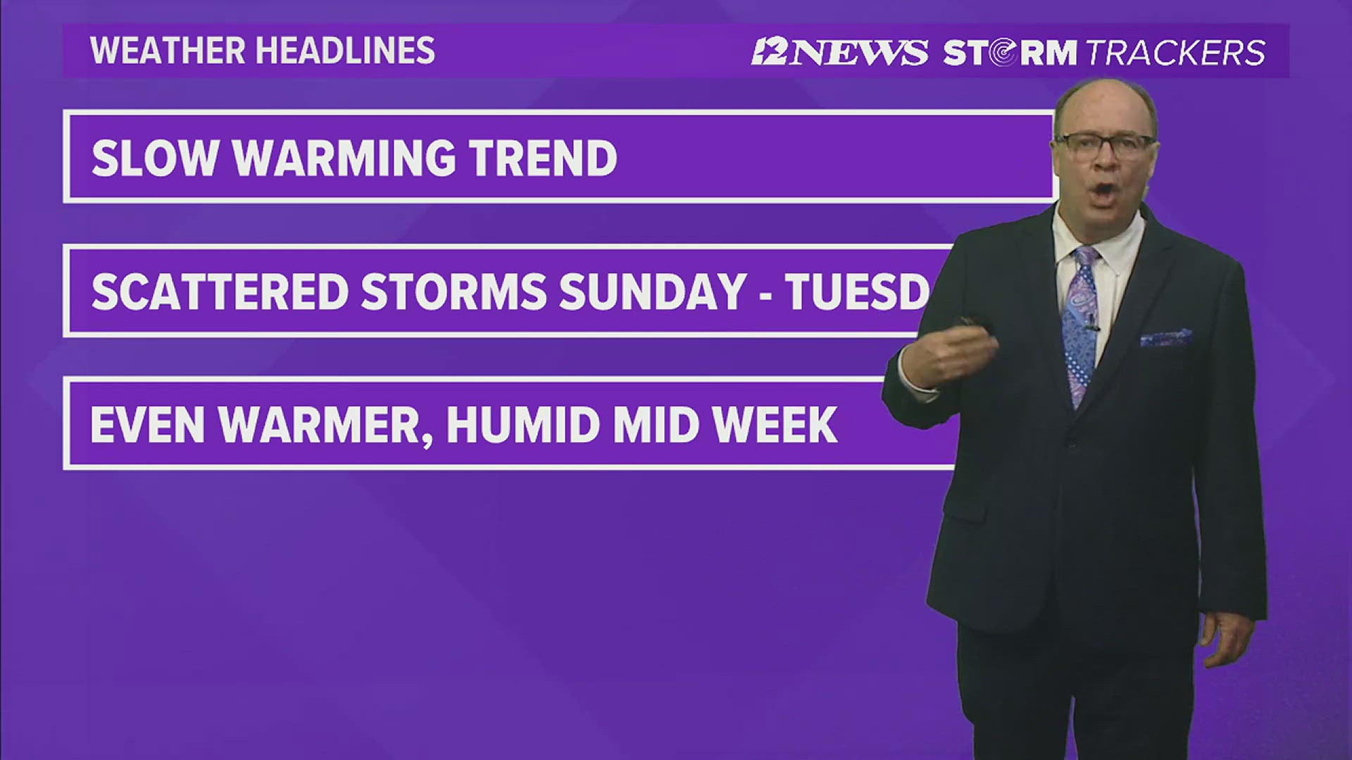
Warm, humid weather conditions are forecast through the end of the week with minimal rain chances. Low temperatures will rise into the lower 70s with highs rising into the lower and middle 80s.
Windy weather is forecast Friday, Saturday and Sunday with wind gusts ranging between 30 and 35 mph as disturbances move northeast through the Texas Panhandle.
Sunday, Monday and Tuesday, scattered to numerous showers and thunderstorms are forecast each day due to a series of upper-level disturbances pushing through the area.
By Wednesday and Thursday of next week, a weak ridge of high pressure will build over the region resulting in mainly dry conditions. Low will be near 70 with highs in the middle 80s.
Friday the 3rd of May, a weak upper-level disturbance, moving through SE Texas, may result in a slight chance of showers and thunderstorms. Low temperatures will be in the lower 70s with highs in the middle 80s.
Southeast Texas weather


Short Term Forecast
Triangle Wednesday Night: Mostly cloudy, warm and humid. Low near: 66° in Beaumont, near: 65° in Orange and 67° in Port Arthur. Winds: Southeast: 3-8 mph.
Lakes Area Wednesday Night: Mostly cloudy, warm and humid. Low near: 63°. Winds: South-Southeast: 3-8 mph.
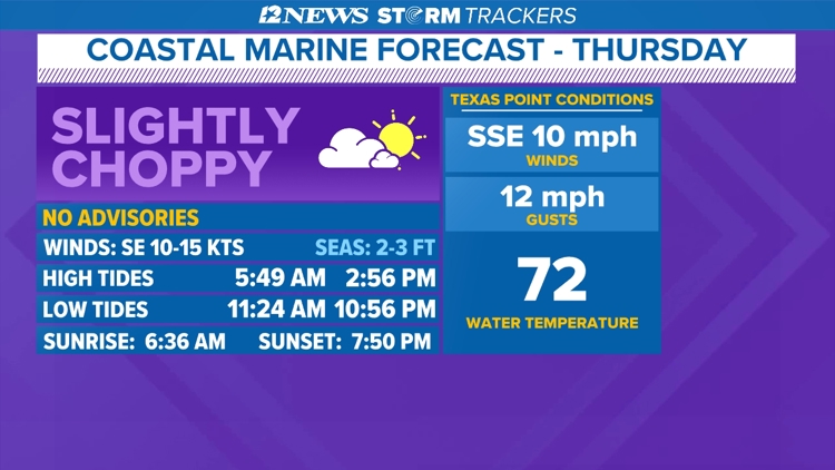
Triangle Thursday: Morning cloudiness followed by a warm, humid, breezy afternoon with decreasing cloudiness. High near: 82° in Beaumont, near: 82° in Orange and near: 81° in Port Arthur. Winds: South-Southeast: 5-15 mph with gusts to 20 mph.
Lakes Area Thursday: Morning cloudiness followed by a warm, humid, breezy afternoon with decreasing cloudiness. High near: 83°. Winds: South-Southeast: 5-15 mph with gusts to 20 mph.
Extended Forecast
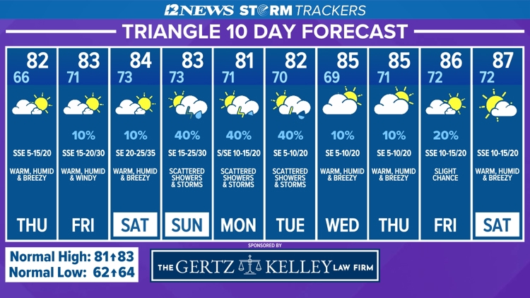
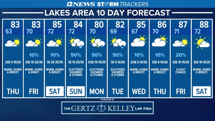
Friday (4/26): Warm morning followed by a warm, humid, windy afternoon with decreasing cloudiness and a 10% coverage of showers. Low near: 71°. High near: 83°. Winds: South-Southeast: 15-20 mph with gusts to 30 mph.
Saturday (4/27): Warm morning followed by a warm, humid windy afternoon with decreasing cloudiness and a 10% coverage of showers. Low near: 73°. High near: 84°. Winds: Southeast: 20-25 mph with gusts to 35 mph.
Sunday (4/28): Warm morning followed by a partly sunny, warm, humid and windy afternoon with a 40% coverage of showers and thunderstorms. Low near: 73°. High near: 83°. Winds: Southeast: 15-20 mph with gusts to 30 mph.
Monday (4/29): Warm morning followed by a partly sunny, warm, humid, breezy afternoon with a 40% coverage of showers and thunderstorms. Low near: 71°. High near: 81°. Winds: South becoming Southeast: 10-15 mph with gusts to 20 mph.
Tuesday (4/30): Warm morning followed by a partly sunny, warm, humid, breezy afternoon with a 40% coverage of showers and thunderstorms. Low near: 70°. High near: 82°. Winds: Southeast: 5-10 mph with gusts to 20 mph.
Wednesday (5/1): Warm morning followed by a partly sunny, warm, humid, breezy afternoon with a 10% coverage of showers. Low near: 69°. High near: 85°. Winds: Southeast: 5-10 mph with gusts to 20 mph.
Thursday (5/2): Warm morning followed by a partly sunny, warm, humid, breezy afternoon with a 10% coverage of showers and thunderstorms. Low near 71°. High near 85°. Winds: Southeast: 5-10 mph with gusts to 20 mph.
Friday (5/3): Warm morning followed by a warm, humid, breezy afternoon with decreasing cloudiness and a 20% coverage of showers and thunderstorms. Low near: 72°. High near 86°. Winds: South-Southeast: 10-15 mph with gusts to 20 mph.
Saturday (5/4): Warm morning followed by a partly cloudy, warm, humid, breezy afternoon. Low near: 72°. High near 87°. Winds: South-Southeast: 10-15 mph with gusts to 20 mph.