
BEAUMONT, Texas —
Forecast Discussion
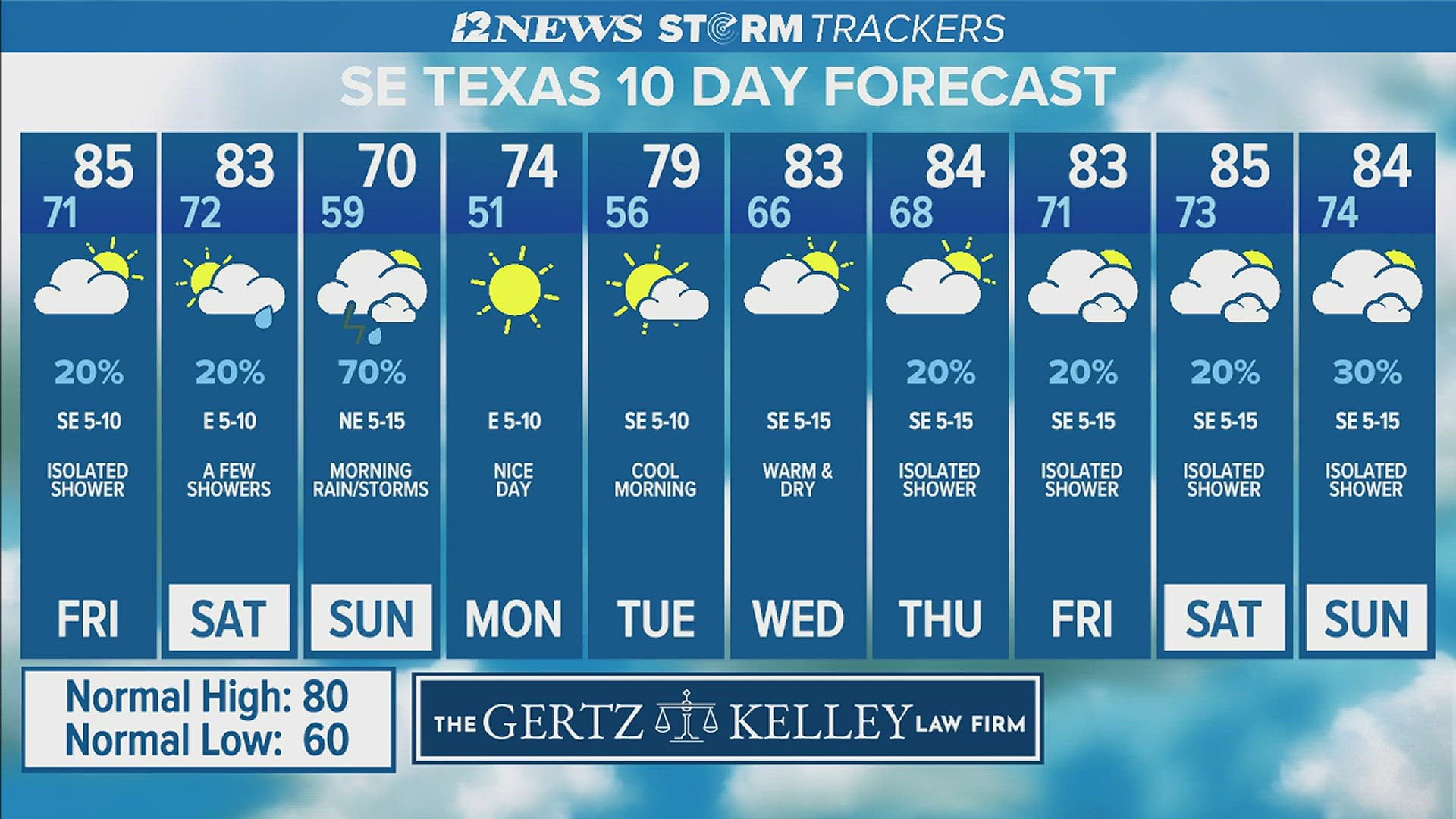
Warm and humid weather is forecast to kick off the weekend. An isolated shower isn't out of the question especially this afternoon.
Saturday, a 20% coverage is forecast for the Triangle and a 40% coverage in the Lakes Area.
Saturday Night, showers and thunderstorms are likely as a cold front sweeps through the area with a 60-70% coverage.
Sunday Morning, shower and storm activity looks to taper off quickly. Sunshine looks to return the afternoon.
Monday and Tuesday Mornings look chilly with pleasantly warm afternoons.
Warmer, more humid conditions are forecast to return mid-week with a 20% coverage of showers and thunderstorms. Next weekend looks warm and humid with highs in the middle 80's and lows in the lower to middle 70's.
A 30% coverage of showers and storms is forecast the weekend of the 27th and 28th with highs well into the middle 80s.
Short Term Forecast
Triangle Today: Warm morning followed by a partly cloudy, warm, humid afternoon. Highs in the middle 80's. Winds: Southeast 5-10 mph.
Lakes Area Friday: Warm morning followed by a partly cloudy, warm, humid afternoon. High near: 85°. Winds: Southeast 5-10 mph.
Triangle Thursday Night: Mostly cloudy, warm and humid. Lows in the lower 70's. Winds: South 5-10 mph.
Lakes Area Thursday Night: Mostly cloudy, warm and humid. Lows in the lower 70's. Winds: South 5-10 mph.
Extended Forecast
Saturday (4/20): Warm morning followed by a partly cloudy, warm, humid afternoon with a 20% coverage of showers and thunderstorms in the Triangle and a 40% coverage in the Lakes Area. Low near: 70°. High near: 83°. Winds: Southeast 3-10 mph.
Sunday (4/21): 50% coverage of morning showers and thunderstorms in the Triangle and a 30% coverage in the Lakes Area followed by a mostly cloudy, breezy, cooler afternoon. Low near: 59°. High near: 70°. Winds: Northeast 10-15 mph with gusts to 20 mph.
Monday (4/22): Chilly morning followed by a sunny, warm afternoon with low humidity. Low near: 50°. High near: 75°. Winds: Northeast becoming East 3-10 mph.
Tuesday (4/23): Chilly morning followed by a warm afternoon with increasing cloudiness. Low near 57°. High near 79°. Winds: East becoming Southeast 3-15 mph.
Wednesday (4/24): Mild morning followed by a partly sunny, warm and humid afternoon with a 10% coverage of showers. Low near: 66°. High near 82°. Winds: East becoming Southeast 5-15 mph.
Thursday (4/25): Mild morning followed by a partly sunny, warm, humid, breezy afternoon with a 20% coverage of showers and thunderstorms. Low near: 69°. High near 83°. Winds: Southeast 5-15 mph with gusts to 20 mph.
Friday (4/26): Warm morning followed by a partly sunny, warm, humid, windy afternoon with a 20% coverage of showers and thunderstorms. Low near: 71°. High near: 84°. Winds: South-Southeast 10-15 mph with gusts to 25 mph.
Saturday (4/27): Warm morning followed by a partly sunny, warm, humid and windy afternoon with a 30% coverage of showers and thunderstorms. Low near: 73°. High near: 85°. Winds: South-Southeast 10-15 mph with gusts to 25 mph.
Sunday (4/28): Warm morning followed by a partly sunny, warm, humid and windy afternoon with a 30% coverage of showers and thunderstorms. Low near: 73°. High near: 85°. Winds: South-Southeast 10-15 mph with gusts to 25 mph.